Heritage at Risk: EU research and innovation for a more resilient cultural heritage
Neglect, pollution, natural hazards and climate change are all playing their part in the damage to cultural heritage. This non-renewable resource, in all its diverse physical forms, needs safeguarding for future generations. EU-funded research projects have been carefully investigating the preservation and the sustainable management of these valuable assets to increase their overall resilience. Innovative solutions and techniques, assessment systems, mitigation strategies, risk management models, disaster prevention, quick damage assessment, ICT tools and guidelines have been some of the major results successfully delivered by both FP7 and H2020 projects in the field of cultural heritage.
History lessons for a more resilient future
© Shutterstock
A wide-ranging EU-funded analysis of rural Western European societies, spanning a period of 500 years, has identified common characteristics that make some societies more resilient against disaster than others. The COORDINATINGforLIFE (Coordinating for life. Success and failure of Western European societies in coping with rural hazards and disasters, 1300-1800) project has found that while rising inequality in itself does not necessarily lead to higher vulnerability, the presence of intermediary groups is often crucial.
Village communities, water management organisations and charities, for example, have historically played a key role in helping societies to prevent and recover from disasters. But with the decline of these middle groups their success in this dwindled. Moreover, the project has shown that when rises in material inequality are not addressed by way of institutional changes, societies do become more vulnerable.
Another key finding has been that while some groups have proven to be highly vulnerable to hazards, others have always managed to escape the ‘storm’. “It is therefore not societies that are hit by a disaster, but very specific groups within society,” explains COORDINATINGforLIFE project coordinator Professor Bas van Bavel from Utrecht University in the Netherlands. “We feel this approach could be a vital antidote against too much of a focus on systemic vulnerability.”
Durable societies
Launched in 2014 and due for completion in 2019, the COORDINATINGforLIFE project has focused on Western Europe in the period between 1300 and 1800. Comparative analyses over this timespan have been carried out to try and identify what determines resilience. Today, societies around the world will likely be confronted with more disasters in the coming decades, particularly as a result of climate change.
This makes it crucial to better understand why some societies appear able to prevent hazards from becoming disasters or, if disasters happen, to cope with them and quickly recover,”
says Prof. van Bavel. “There is also a growing consensus that relying on technological solutions and material resources alone will not suffice.”
Prof. van Bavel points out that wealthy and technologically advanced countries are not spared disasters, as demonstrated all too clearly by the Fukushima disaster in Japan. This is why answers are increasingly being sought in the organisational capacities of society. “We know very little, however, about what these capacities are, and why they sometimes are successful in facilitating recovery and sometimes not,” says van Bavel.
History as a laboratory
The approach taken by the project has been to consider history as a living ‘laboratory’, where historical records can be analysed to test hypotheses. The long historical perspective of the project has enabled the team to compare widely differing cases and achieve insights into the relative performance of these societies.
“Another interesting element of this project is that it combines history and historical methods with insights and expertise from economics, geography and climatology,” says Prof. van Bavel. “Our work has relevance for scholars working in the natural sciences, including the fields of climate change and epidemics. A key aim has been to enrich their understanding of present risks by adding an historical perspective.”
The project team is currently working on a textbook entitled ‘History and Disasters’ – aimed at a wide audience of scholars from all disciplines, students and practitioners – and is developing links between historical research and current policy. This is being achieved not only through disseminating findings, but also through direct contact.
“Project members are actively involved in networks on current climate change research and policy and contribute to briefing documents aimed at academics, NGOs and government agencies,” says Prof. van Bavel. “Moves to integrate historical knowledge into present-day flood protection schemes have already resulted in active collaboration in a Belgium-Dutch Estuary Restoration project (the Hedwige-Prosperpolder project), as well as several targeted presentations. In the longer term, this may result in a tech-transfer project, provisionally labelled ‘Building with nature and history’.”
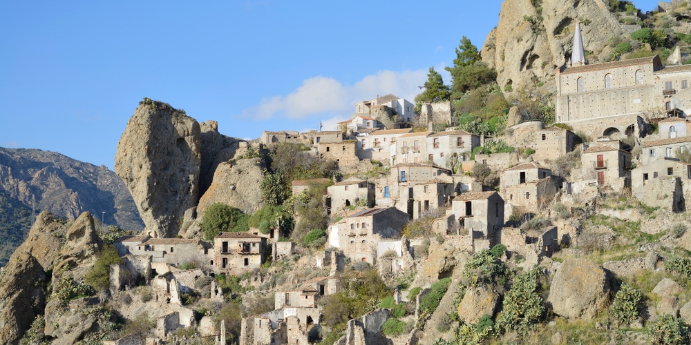
Malta: a case study in the rise and fall of civilisations
 © Fragsus
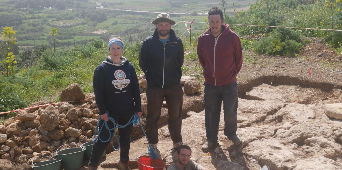
Evidence from ancient cereal pollen samples, erosion and tree felling has given EU-funded scientists the clearest picture yet of the complex and hidden history of ancient Malta. The findings could help us understand how cultures become sustainable, or collapse. Humans arrived in Malta at least 700 years earlier than previously thought, the ground-breaking Fragsus (Fragility and sustainability in restricted island environments: adaptation, cultural change and collapse in prehistory) project has revealed. “Malta experienced two or three episodes of colonisation, possibly with gaps in human occupation of as much as 1 000 years,” says project coordinator Professor Caroline Malone, from Queen’s University Belfast in the UK. “This was never suspected before. In fact, little research has been directed towards understanding why colonial experiments fail or succeed on small islands.”
This was a key objective of the Fragsus project, which has examined the impact of the first human settlements on Malta to assess the rapidity of deforestation, erosion and degradation. The results have sparked great interest in Malta, where tourism forms a critical element of the economy. They could potentially boost the conservation of valuable heritage sites on the heavily urbanised and populated islands. Over a quarter of the islands are already under concrete.
The project has also involved around 100 students in on-site excavation work and led to five ongoing PhDs, helping to ensure that Fragsus’ work will continue into the future. A follow-on Marie Curie-funded project will now use project data to better understand Malta’s ancient past.
Uncovering Malta’s past
When Malta was first colonised in the 6th millennium BC, pristine soil and forest covered the landscape, but within centuries the landscape was bare and under intensive cultivation. A temple culture emerged out of this precarious environment, which was sustained over centuries. “There is something about small geographic spaces that gives rise to intense, complex social states,” says Prof. Malone. “Think of Cyprus, or Easter Island.” Some 2 500 years after the first settlement however, this unique and isolated socio-economic system apparently collapsed.
“Malta has some of the most distinctive archaeology in Europe, which has never been fully appreciated,” explains Prof. Malone, who has spent more than 30 years pioneering excavations on the islands.
The rapid rise in population density, wealth and with it the destruction of the island’s heritage and landscape made a pressing case for further investigation."
The team set itself some ambitious questions. For example, how did a very small island community in prehistoric times manage to sustain complex life over millennia and were the monumental temples instrumental in the process of sustaining cultural life? The Fragsus project also sought to identify the socio-economic or environmental failure at the end of the island’s temple culture, which may have caused society to collapse or to drastically change.
“We tackled these questions through archaeological surveys and excavations as well as soil extractions containing ancient pollens and invertebrates,” she explains. “The project has been a melting pot of ideas. We also analysed dietary and DNA data from a large burial complex to provide a human dimension to archaeological evidence.” Finally, radiocarbon dating helped the team to build a robust chronological “calendar” of time and change on the islands.
Fragile past, fragile future
Some of the findings of the project, which ended in April 2018, are on show at an exhibition at the National Museum of Archaeology of Malta in Valletta. This show encapsulates the project’s ambition of raising awareness of Malta’s unique and little-understood ancient past, which in many ways echoes current environmental predicaments on the densely populated and urbanised islands.
“We hope archaeological approaches will be transformed,” says Prof. Malone. “We have highlighted the importance of gathering DNA samples and shown that this can be done in southern Europe, where previously it was thought that heat damage made this impossible.”
Project results will continue to be published for some time to come, while digitised human remains can be used in further studies. “Our hope is that Fragsus will have a lasting impact on conservation work in Malta, and that this will be accelerated in the future,” she adds.
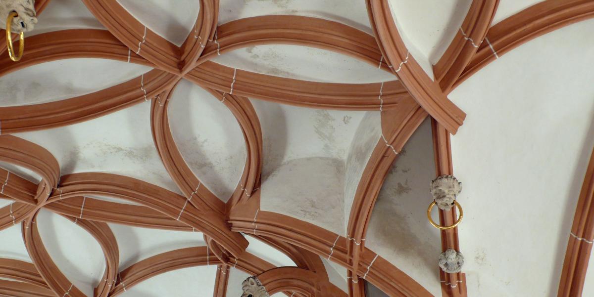
New insights into how the great Gothic vaults were constructed helps restorers of the future
 © M.J. Ventas Sierra
The question of how medieval architects communicated their fantastically complex designs for some of Europe’s most beautiful Gothic vaulting has perplexed researchers. Now a hands-on approach provides insights that will help conservationists. When it comes to the fantastically intricate design of Gothic vaulting and ribbed arches, we have had very little knowledge of how architects communicated with master masons. The few sketched-out plans that exist, such as that for a part of the Cathedral of Strasbourg, show a surprising lack of written instruction and even measurements are missing. With the architect in a different place to the building site itself, the question that has baffled researchers in this domain is: how did such complex structures make it from two-dimensional drawing to the great, three dimensional vaults that captivate us today?
Finding the answer was the primary goal of the EU-funded REGOTHICVAULTDESIGN (Design Principles in Late-Gothic Vault Construction – A New Approach Based on Surveys, Reverse Geometric Engineering and a Reinterpretation of the Sources) project. As project coordinator Dr David Wendland explains, “Until now our knowledge has been mainly based on sources which, in some aspects, appear incomplete. The innovative approach of the project consists in formulating hypotheses on the design directly from the built artefact, with a working method not common in surveying until now.”
Although an interesting conundrum in its own right, the question also feeds into restoration and maintenance: good conservation practice benefits from the ability to draw on original techniques.
Exploring techniques of medieval master masons
The stonemasons’ knowledge was shared orally, in lodges and workshops. One such workshop, which was involved with the building of Strasbourg Minster from the 12th to 16th century, is still up and running. Historically accurate stonemasonry techniques are taught there today, which made the workshop a logical participant in Dr Wendland’s research.
To establish how the master masons of 500 years ago went about their work, and to work out how they instructed the cutters to size the stones with such geometric precision, Dr Wendland and his team reverse engineered, among many others, the ribbed vaulting of St Anne’s church in Annaberg, and the Palace of Meissen, Germany.
“These structures are extremely complex in their geometry, with complicated meshes of ribs soaring along three-dimensional curves and intersecting on multiple levels at the keystones,” says Dr Wendland, who was based at the Technical University of Dresden, Germany.
One technique the project employed was to create a large expanse of plaster surface (10x15 metres), which was formed into a ‘tracing surface’ at the University of Dresden. Tracing floors were a standard technique used at the time and researchers were keen to replicate the process, using only squares, compasses and rulers.
A drawn out process
Using the tracing floor and the instruments the original masons would have employed, the team drew out the pattern for the vault at Meissen. “Representing the three dimensional on a flat plane was a real challenge,” Dr Wendland explains. Once the design was mapped out on the plaster, the researchers compared the pattern with the dimensions discovered through their survey of the original vault.
Copper templates, referred to in some manuscript descriptions of the task, were used to transfer flat designs to the three dimensional stone carving. “We tested our theory using gas blocks as they are easy to carve and allowed us to carry out rapid trials,” he says. However, their system proved to be robust and the work moved onto quality stone quite quickly.
21st century master masons, 500 year-old know-how
Academic research was not the sole aim of the two projects. Of equal importance to the Franco-German team was the dissemination of ‘living knowledge’. To that end, apprentices at the stone masons’ workshop were involved in the carving. As Dr Wendland puts it, “The knowledge of the historical procedure in planning and setting out is now available for anyone working on the restoration of historic vaults. Involving young professionals in this is vital if the information is to be transmitted.”
He goes on to explain that the idea behind the whole project is not only to rediscover and understand historical techniques, but to incorporate them into current restoration practices. “Restorers should at least have the option of using historical setting-out, planning and cutting techniques.”
Long-term research with even longer-term goals
The team’s work was carried out over the lifespan of two EU-supported projects. Building on the processes explored by REGOTHICVAULTDESIGN, which focused on surveying, the second phase, called REGothicVaultElements (Late Gothic vaults and their complex stone members: Recovering historical design procedures, implementing knowledge in restoration practice), concentrated on replicating construction techniques.
These projects have enabled us to gain a deeper understanding of the principles of the geometric design and how the instructions for producing their single stone elements were formulated. These insights will feed into the conservation practices of the future,” says Dr Wendland.
Novel methods in 3D reconstruction can offer heritage preservers and curators new insights
 © Shutterstock
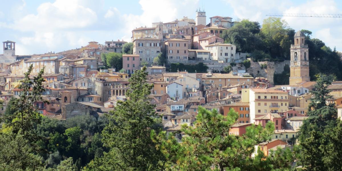
Most existing solutions for urban modelling generate dense geometric models that are accurate and visually faithful, but that come with no structural or semantic information. As a result, applications that often require structured scenes cannot readily use them. Large-scale cultural heritage scenes are not just complex ‘shapes’, they are hybrid scenes composed of both free-form shapes (land, trees) and myriads of objects that have structural relationships and semantic meaning (such as walls, roofs, façades). One category of existing solutions generates faithful city models enriched with structural and semantic information, yielding meaningful levels of detail. However, producing these city models requires many labour-intensive modelling and editing operations to assign semantic labels to data, then to reconstruct.
The EU’s TITANIUM (Software Components for Robust Geometry Processing) project tackles the problem of 3D reconstruction and simplification of data gathered from raw geometric measurements, as well as related conversion methods specifically tailored to 3D urban modelling. Raw data are 3D point clouds either measured by laser scanners or generated by dense photogrammetry algorithms (which convert a set of photos into 3D point clouds with colour attributes).
As lead researcher Dr Pierre Alliez, based at the Institut National de Recherche en Informatique et Automatique (INRIA) in France, explains,
From existing research prototype algorithms, our goal is to develop a software demonstrator for geometry processing and 3D urban modelling, in order to facilitate the pre-commercialisation of novel software components for the Computational Geometry Algorithms Library.”
Pioneering novel formulations
On robust shape reconstruction, Dr Alliez explains the project pioneered novel formulations based on the theory of optimal transportation. This involves input geometric measurements (raw point sets) as discrete measures (a distribution of masses). The reconstruction problem is reformulated as a mass transportation problem between the said masses and reconstructed surfaces.
“Spatially-variable noise, increasingly common in low-cost geometric sensors, is handled via a novel automatic scale selection approach, which relies on the sole assumption that the inferred shapes are manifolds of known dimension.” The project chose these methodologies because they offer unrivalled resilience to noise and outliers.
Regarding the enduring problem of robust shape approximation, TITANIUM developed a novel approach that reduces the geometric complexity of a shape, while remaining within a tolerance volume and providing topological guarantees. “This approach best illustrates our initial goal to devise methods that can take defect-laden data as input, and yet provide guarantees as output,” says Dr Alliez. He adds, “Although our research directions remained within the field of computer science, we enlarged our focus to topics commonly tackled within the fields of robotics and computer vision.”
Societal benefits
Societal benefits of the project include the potential for supporting sustainable urban design, since computational engineering also applies to simulations of physical phenomena at the scale of entire cities. The impact of the proposed demonstrator will be significant in applications where geometry acquisition and processing play a central role (e.g., geographic information systems, computational and reverse engineering).
Dr Alliez explains, “Our industrial contacts have told us that the process of converting raw data into defect-free models ready for simulation is by far the most labour-intensive part of the design cycle (accounting for 85 % of time spent vs. 15 % for the simulation). Our demonstrator has the potential to significantly reduce the duration of this process, offering increased economic competitiveness.”
The project’s findings can also feed into conservation work. Detecting and enforcing structural relationships translates into the detection of near adjacencies and canonical relationships, followed by their reinforcement by quantisation into exact relationships. Structure and semantic information are then used to recover levels of details. “This would improve the scanning of either a historical site or an entire collection whose pieces are possibly disseminated,” says Dr Alliez.
Going forward, TITANIUM’s results can lead to the development of the concept of collaborative digitisation and active digital resources. In the context of a multidisciplinary collaboration, the objective is to design hybrid systems in which communities (via social networks) and networks of sensors cooperate.
New radiocarbon dating techniques reveal secrets of early Saharan civilisation
 © Trans-Sahara
Latest research reveals that the Sahara was much more densely populated in the pre-Islamic era than previously believed. Findings now show that oasis settlements played an important role and that trade was developed alongside the spread of irrigated agriculture.
The key questions that arise from research into the desert region of North Africa concern the nature, sophistication and connectedness of the first oasis communities in the Sahara. The traditional view, fostered by the legacy of modern colonial government in North Africa, is that the Sahara was lightly populated apart from a few wandering nomads in the pre-Islamic age.
The EU-supported TRANS-SAHARA (State Formation, Migration and Trade in the Central Sahara (1000 BC – AD 1500)) project has challenged that position by exploring several key themes: trade, settlement type and economic activity, technological change, burial rites and identity, and migration.
Ground-breaking discoveries despite severe constraints
The impossibility of conducting field research in the Libyan Sahara as a result of the 2011 civil war meant the project used satellite image analysis and targeted radiocarbon dating of mudbrick settlements to gather part of its data. “This enabled a dramatic expansion in knowledge of pre-Islamic oasis settlement in several Libyan oasis zones; with global publicity for the discovery of hundreds of towns and villages of the ‘lost’ Garamantian civilisation,” explains lead researcher Professor David Mattingly.
The results clarify the scale and sophistication of Garamantian society, which, says Prof. Mattingly, began around 1000 BC. In the period AD 1-600 it arguably constituted the first pre-Islamic state of the central Sahara.
Development around oases earlier than thought
More recently, Moroccan fieldwork, starting with satellite mapping and follow-up ground visits to collect dating evidence (including another substantial suite of radiocarbon dates), has revealed a similar pattern of precocious oasis development. This, the project believes, is linked to other markers of social change (metallurgy, hierarchy and complexity). “The development seems to have occurred at a later date, beginning in the first half of the first millennium AD, with the region becoming influential in the formation of powerful Islamic states in the early medieval period,” Prof. Mattingly explains.
One of the most remarkable discoveries of the Moroccan fieldwork was the discovery of a type of tomb with painted funerary chapels used for ancestor worship. So far TRANS-SAHARA has established a corpus of 20 painted human figures (such as the illustration), providing a remarkable window into desert society, dress, accoutrements and aspects of ritual and belief.
Prof. Mattingly intends to take these findings further, “We plan to excavate further tombs in a future phase of the project. Another of the Moroccan settlement sites has yielded a remarkable dossier of hundreds of engraved rock art images: mostly of horses with mounted warriors, seemingly linked to a horse cult of some sort. We believe that discoveries like these will help the Moroccan authorities develop visitor attractions/museums in the study zone.”
Pioneering dating techniques provide a clearer idea of context
The greatest challenge to the historical archaeology of the Sahara has been the lack of chronological precision. Numerous archaeological sites are known for the historical context being entirely lacking. The TRANS-SAHARA project has pioneered a method of dating mud architecture using radiocarbon (AMS) methods on organic inclusions in mudbrick.
This has proved extraordinarily useful in providing clearer dates for a wide range of sites spanning the pre-Islamic and Islamic eras. A total of c. 200 AMS dates were funded by the ERC, providing an entirely new framework for oasis development across the Sahara. He adds, “If our dating approach is extended to further sites, the regional trajectories of development will become clearer.”
Fostering collaboration to create new approaches
As well as meeting its scientific objectives, the project served to advance the careers and intellectual development of a cohort of early career researchers. The conferences fostered working relationships and collaborations that went beyond the core project, some of which are ongoing.
The TRANS-SAHARA project has re-oriented the future agenda of study of Saharan history and archaeology, with important implications not only for scientific study, but also for the national identity of Saharan and Maghrebian countries,” Prof. Mattingly explains.
These articles were first published in CORDIS Results pack Heritage at Risk: EU research and innovation for a more resilient cultural heritage


